
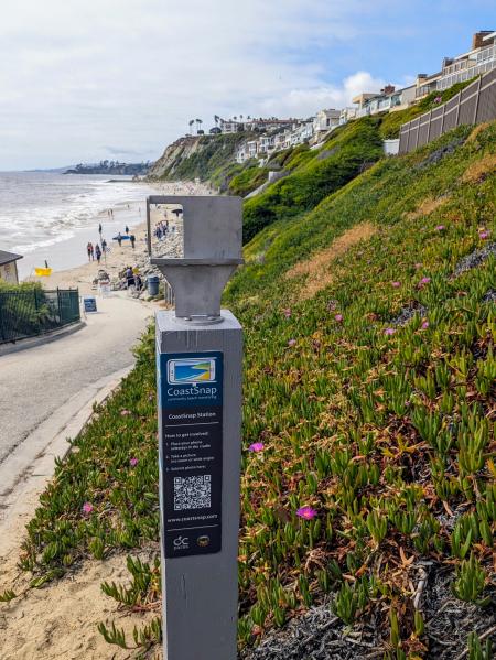
(Dana Point, Calif.) – OC Parks recently installed the first community-driven shoreline monitoring location in Orange County. Located along the Strands Beach access ramp (map included in Press Images), the CoastSnap station encourages community members to help with coastal monitoring efforts.
The CoastSnap station includes a smartphone cradle and instructions on how to upload and submit a photo of the shoreline. Residents and visitors alike are invited to place their phones in the cradle and snap a photo. The cradle is set at a precise location and angle to ensure the public is capturing consistent images. Afterward, the public is asked to scan a QR code to then upload the photo. From there, the images are sent to OC Parks and will be used to assist with monitoring seasonal and long-term beach width. The cradle works in conjunction with surveyed control points and time stamps allowing for photos to be stitched together, accounting for tidal variations.
“I am excited to bring the first CoastSnap station to Orange County and harness the power of the community to help protect our coast,” said Supervisor Katrina Foley, Orange County Board of Supervisors. “Coastal erosion threatens our coastal communities, economy and way of life here in Orange County. This CoastSnap station serves as a valuable tool to measure how much coastal erosion impacts our beaches. By engaging residents in this important endeavor, we will gather valuable data while serving as good stewards over our beaches.”
CoastSnap, developed by researchers from the University of New South Wales (UNSW Sydney), is a global citizen science project to help researchers better understand the coastlines and safeguard them for future generations. Currently, there are five other CoastSnap stations in California located in San Diego County. In addition to the CoastSnap station, a new interpretive sign has been installed complementing the CoastSnap station with narrative descriptions and images demonstrating seasonal and long-term changes of the shoreline.
The installation of the CoastSnap station marks the completion of the Niguel Shores Revetment Restoration Project. As part of the Coastal Development Permit issued by the California Coastal Commission for this project aimed at enhancing shoreline protection, OC Parks is responsible for complying with a Shore Zone Monitoring Plan. Seasonal transect surveys will be conducted to monitor any movement of the revetment and photos collected through the CoastSnap station will further aide in these efforts.
Read this release in:
###
OC Parks
OC Parks manages nearly 60,000 acres of parks, historical and coastal facilities and open space for the County of Orange as part of OC Community Resources. http://www.ocparks.com
Links in this section relate to Body